Expert Q&A: Jessica Webb, Global Forest Watch
By Amy Nelson
What are the components of Global Forest Watch?
Global Forest Watch has two main components. One is a suite of on and offline tools that enable anyone around the world to have free, open public access to information that can help them understand how and where forests are changing. But it is also a partnership of data providers, technology providers, and users of data and tools who are applying them in different ways to be able to monitor and sustainably manage forests globally.
How does Global Forest Watch define a forest?
As your readers probably know, by some counts, there are more than 800 definitions of a forest. Technically speaking, Global Forest Watch provides data on tree cover, which is derived from satellite data and thus cannot discern whether or not these trees exist within natural vs. plantation forests and what land use decisions are affecting them. The data tells us information about height, canopy cover, and extent of trees, but using the interactive, online Global Forest Watch platform, users can filter this data based on their preferred definition of forests. We added functionality so that data can be filtered according to what users consider the minimum threshold in terms of tree cover canopy density or tree cover heights. We include contextual datasets on extent of primary forest, plantation forest, and other forest types, so users can include or exclude those forest types according to their definitions. Generally speaking, we are talking about tree cover in this context which is defined in datasets on GFW as all vegetation taller than five meters in height.
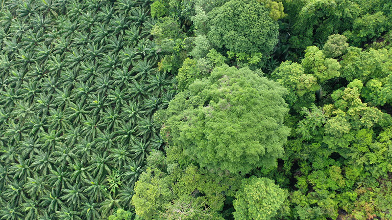
The core datasets on Global Forest Watch, which show tree cover change, are derived from free satellite imagery archives from NASA (Landsat) and the European Space Agency (Sentinel). These archives are free and open to the public, but there are thousands of new images every day, and it would be impossible to manually review each one and see when there is a change from one day to the next. That’s where algorithms come in. In relation to tree cover, tree cover loss, and tree cover gain, those algorithms primarily come from research partnerships we have with universities such as the University of Maryland’s GLAD Lab, and Wageningen University & Research in the Netherlands, with some data products coming from WRI as well.
Using the Landsat and Sentinel archives, we and our research partners are able to train algorithms (through machine learning) to automatically detect and identify where change has occurred. With that information, through on-the-fly analysis tools on the platform, even users without any knowledge of GIS can select a polygon and do some calculations (adjusting the definitions of forest to meet their own specifications). Users can also adjust time periods and generate analyses on net changes in terms of forests within an area, as well as other information such as the related carbon flux (carbon removals and emissions related to tree cover change within their area of interest.) There are hundreds of other contextual datasets—on anything from where palm oil or mining concessions are to which areas are owned and managed by Indigenous communities, and other information about land cover types—that people can use to create their own analyses and maps depending on their objectives.
At what resolution does that data come?
For the core datasets on forest change, which come from the Landsat imagery, it is 30-meter resolution. The Sentinel imagery is at 10-meter resolution.
I understand (from information recently shared by Global Forest Watch) that loss of primary forest in the tropics has actually increased by 10% in the last year, and that 43% of that loss occurred in Brazil. What else is Global Forest Watch telling us about the state of forests today, and what kinds of information is it revealing that we might not have been able to know without it?
Before Global Forest Watch launched, there were regular forest assessment reports, but they were on paper, and they came out every five years. It was really challenging to get an accurate and frequent understanding of forest change. Now, within a few months into a new year, we’re able to understand, from the year prior, trends in net forest change. Because the methodology is global, we are also now able to compare across different areas because we’re using the same standard and definitions, whereas previous reports were based on self-reporting countries’ own definitions of forest and forest change. Countries have different types of forests and different sorts of political commitments and agreements, so there is definitely a place for that, but it’s also very helpful to be able to see trends across countries using the same methodologies and definitions.
Is there data that can help us understand how much of recent tropical forest loss is attributed to wildfires vs. agriculture vs. other causes?
We are constantly improving and iterating on the data that is available to be able to get from “what is tree cover loss?” to “what is actual deforestation according to the different definitions that different folks have?” We have hundreds of contextual data layers and analyses that help to provide additional insight into what is driving that change in specific cases. We have one dataset specifically on tree cover loss due to wildfires. You can go onto the platform and do some analysis for any country or area you’re interested in to be able to see that.
We also have a model of deforestation drivers, which attributes the likely cause of the tree cover loss for specific areas. That driver’s model is currently available at a 10-kilometer resolution, and we are working this year to improve it to 1 km and then eventually to match the Landsat resolution of 30-meters.
What can you tell us about the users of Global Forest Watch? Who are they?
Global Forest Watch has had nearly seven million users since launch—about a million unique users per year—and they come from every country on the planet. Visitors to the Global Forest Watch website include anyone, from policymakers looking to make informed land use planning decisions or monitor their own compliance with international agreements to banks and financial institutions who are monitoring risk in terms of lending to companies involved in agriculture production. Buyers of soft commodities—particularly those who’ve committed to zero deforestation or zero conversion—can use Global Forest Watch to identify locations within their supply chains that might be in non-compliance with those agreements. Global Forest Watch users also include journalists who are writing stories about illegal deforestation, conservation organizations who are monitoring habitat loss, and funders of conservation projects who want to monitor the impacts of their investments. Users also include civil society organizations who are monitoring specific protected areas for conservation concessions or biological corridors, and Indigenous peoples and other local communities who are focused on defending their territories. Researchers studying forests and forest cover change are also primary users of Global Forest Watch.
Many Leaf Litter readers are involved in ecosystem restoration at a variety of scales. Are restoration practitioners users of Global Forest Watch?
That is a very timely question. A challenge with monitoring through remote sensing and satellite imagery has been that it is relatively easy to detect when tree clearing has occurred because it is so abrupt: one day, the satellite passes over and detects intact forest and the next day, the satellite passes over and the forest has been cleared. The algorithm can easily detect that. Whereas when trees grow back, that’s a much slower process, and much harder to detect.
There are, however, a couple of new datasets in the works that have been very helpful for that. One is a tropical tree cover dataset based on the Sentinel satellite imagery archive that uses both optical and radar data to create a very high-resolution map of tree cover. That dataset has been very helpful in detecting reforestation and tree cover change outside the forest—places like urban forests or cropland or dry lands or other types of areas that weren’t able to be mapped through datasets that we had in the past. The University of Maryland is also using more LIDAR data, which can evaluate tree cover heights as a way to create an annual tree cover gain layer. Right now, the gain layer that’s on Global Forest Watch from the University of Maryland is only for the 20-year period of 2000 to 2020. We have a sense of how much gain there has been, but it’s just over that 20-year time span. I believe sometime within the next year they’ll come out with an annual product, so for each year, we’ll be able to see how much tree cover was lost and gained in different places. That will be very helpful for restoration.
In what other ways is Global Forest Watch using AI and machine learning to advance its mission?
The tree cover loss algorithms receive training data that comes both from the field and online manual analysis of the satellite imagery. The algorithm then learns to detect, in different circumstances, what has changed and what has not changed. That is regularly being updated as new and better information comes along.
Machine learning is also applied to Global Forest Watch’s alert products. These products are used primarily for detecting and rapidly responding to recent deforestation. Annual tree cover loss is helpful to understand trends over time and the extent of forest area that was lost in a given year, but the alert data was created to be as frequent as possible.
The alert data errs on the side of false negatives over false positives [for forest loss detection], in recognition of the fact that field patrols are costly. You may see an alert in the middle of the forest about a kilometer away as the crow flies, but getting there may involve going up and down a ravine, crossing a river, etc. It can be difficult to actually get to these places, so we want to make sure that there really is something happening with the alert data. The algorithms [used with the alert products] are a little bit different [than those used in tree cover analyses] since they are designed with different use cases in mind, but the same machine learning, in terms of an automated detector of change, applies.
I’ve heard about alert systems in wildlife conservation that predict where poaching is likely to occur. Does Global Forest Watch help users predict where forest loss may occur?
We’ve been involved in some working groups and experimentation on predictive models. They really serve as a risk or vulnerability analysis because we’re saying, “these are the areas that, based on historic information, are likely to be most vulnerable.” Prediction is tricky. You don’t want to be too liberal with it because then it increases the potential for inaccuracy, but if you’re too conservative, you might as well just use the real time data because new images come out on a daily basis.
WRI notes that 70 million Indigenous peoples rely on forest resources for their livelihoods. How is Global Forest Watch supporting the protection of forests on Indigenous lands, and can you tell us about the process of engaging and working with those communities?
Indigenous peoples and other local communities are certainly at the heart of the mission of Global Forest Watch to democratize data. Historically, satellite imagery has been available for a long time, but access was a huge issue. People had to pay for images, and they didn’t have the capacity to analyze them because of the expense involved. You would get one image, which is one snapshot in time for a particular area, but if you wanted to see change or be able to prove or provide evidence of change, you’d have to pay for another image. Global Forest Watch succeeded in leveling the playing field for access to data and information that historically was only held by elites. This has been really powerful for Indigenous communities.
I’ve worked with quite a few community-based organizations to do field work and training. Going out into community areas and just being able to look at a map with recent satellite imagery or alert data has been empowering for a lot of communities. They feel like they’re really being seen, and they are amazed that anybody in the world can go to the platform and see evidence, for example, of how the activities of a mining company are invading their territory and illegally clearing trees. It can be very empowering, and also very helpful in terms of being able to provide documentation and evidence to others to back up their claims that there is encroachment into their territory.
Indigenous peoples and other local communities are certainly at the heart of the mission of Global Forest Watch to democratize data.
The Global Forest Watch platform is an online platform by necessity because data in the cloud is constantly being updated and renewed. One limitation we heard from Indigenous and other local communities and stakeholders was of internet access, given that connectivity in a lot of remote areas still doesn’t exist. So a few years ago we developed a mobile app called Forest Watcher, which enables users to be able to download the alert data, related satellite imagery, and other contextual datasets to be able to use and access the information offline. It also provides a geolocation marker, which shows you where you are in relation to the alert and how to navigate to the alert area. Users of the app can create customized forms for forest monitors to use in providing photos and information about what they’re seeing on the ground. Users can then go back and download the reports and then export them into whatever formats the communities or stakeholders need in order to pursue legal action or create an advocacy campaign. Of course, all data they collect is secure and private, and they choose who to share it with.
We’ve heard a lot from communities that historically, a lot of organizations would come in to help out with data collection, but then oftentimes that data would leave with the researcher or organization, and the communities would never know what happened to it. It was very important to us to invest in tools and processes that enable data sovereignty and capacity transfer so that communities are fully able to manage the data and tools on their own. It’s all free. We’re there to support if they need it.
How do Indigenous communities hear about Global Forest Watch, and how do you make those first connections and build relationships?
It can happen in a bunch of different ways. With over a million users of Global Forest Watch a year, we obviously do not have direct contact with everyone. Many people find the platform or tools by word of mouth or Google search. We have tutorials, webinars, and all sorts of resource materials available through our online Help Center, and they are translated into six languages, as our goal is to help people to be able to use the tools on their own.
An Indigenous community might hear about the ability to be able to detect deforestation through Global Forest Watch’s alert products, as well as recent high resolution satellite imagery that is used in conjunction with the alerts, through their partner networks or other communities who are already using the data. (Alerts are often an early warning indicator of where something might be happening, and the recent satellite imagery may help identify the potential cause.)
In terms of engaging with communities to use the data for deforestation monitoring and land defense…territories tend to be quite large, and there are often many dozens of Indigenous communities within the territories, and each community has dozens of families. We typically begin by identifying a technical specialist, leader, or pre-established group in the community that already tends to be involved in environmental monitoring in some way, including using traditional knowledge. Often there is some sort of governance body or mechanism like a general assembly that we will engage with who will then identify who has which roles: Who is going to do the administration and coordination of the monitoring? Who will do the field visits and patrols? Once roles are defined, a typical workflow is for the administrators, managers, and/or coordinators to receive some advanced training on the Global Forest Watch desktop applications. They will then monitor where all the alerts are happening within a given territory and prioritize those areas that should be investigated further. Then they will typically communicate with the one or two field monitors who would be closest to the affected area to organize a patrol where the alerts were detected. Sometimes drones are used to get close enough. The community monitors fly the drone and see what’s happening, take photos and videos and document the cause of the deforestation, and then bring that information back to the community.
The administrator, coordinator, or manager then collates that with other reports that have been taken, and usually presents the information and evidence to the general assembly and community leaders or elders, who collectively decide what to do with the information. They may file an official complaint to the environmental prosecutor or environmental police in the area. Or maybe it’s a situation where a neighbor wasn’t aware that they were crossing the boundary into the territory, so they may go out or with an official letter and map and say, “Hey, this is our boundary. Please don’t cross it again.” In the absence of response from law enforcement, they might create an advocacy campaign. For example, if an oil company keeps encroaching on a territory, they may launch a social media campaign or work with an advocacy organization or journalists to get the word out.
Can you share an anecdote where you were actually involved in one of these efforts and data sovereignty was maintained and the community shared the information, took action and forests were saved, or forest loss was stopped?
I was in the Madre de Dios area of southeastern Peru, working with an Indigenous community that was concerned about a particular area [within their territory] where they had heard illegal logging was happening. I was there as part of a consortium of international and community-based organizations that receive funding from a funder in the Netherlands to support Indigenous communities in the Amazon with integrating technology into forest protection. We had all previously gotten together with community technical specialists and leaders, co-designed the project, created a shared work plan, and set up the monitoring processes. When I arrived on this particular trip, we looked at the Global Forest Watch site, reviewed the satellite imagery, and saw that in fact, there were some alerts in the area of concern. By looking at the historical time series of the alerts, we were able to pinpoint when the deforestation started happening.
We planned a patrol, communicated with the community closest to the alert, and organized all the transport. (We took a bus to a Jeep, to a boat, to a Jeep, to a boat, to walking four kilometers in the forest to reach the community.) We coordinated and shopped for all of the supplies, which included our food and fuel for a week, but also other items that the community needed to take advantage of the long journey. We made our way out to the community, talked about the monitoring plan, reviewed the map and the route we were going to take, and packed up all the gear and equipment. In this particular case, because the community territory also has legal designation as an officially recognized protected area, we went with a park ranger as well. In case of any kind of potential conflict, having the ranger provided a little bit more weight in this particular situation. The community and the park service have a very good relationship since they co-manage this area.
We then set off into the forest. It took a lot of time to get to the site, and we spent the night out there. We got as close as we could to the area and did some drone surveillance. We saw that there was some logging equipment, so we proceeded to the area and took photo and video documentation. The rangers are authorized to destroy any logging equipment they find, sometimes by setting it on fire. Some of the machinery was warm, so I think that they heard the drone and took off. The ranger destroyed the logging equipment as much as possible, and we all returned to the community and eventually the home base. The community representatives and the ranger put together an official report documenting what they had seen and observed, and that area was then flagged as a high priority for follow up monitoring and investigation.
It was very powerful. The alerts were so helpful because this was in the middle of nowhere. There is no road, and the community was over a day’s walk from there. It was very selective logging for high value timber, and no one would’ve known about it without the alert information.
In tackling deforestation as a whole, there are so many challenges. But with communities like this, these are their homes–their ancestral lands–and they are under constant attack and encroachment. Their lives and their livelihoods are impacted. There can be considerable risk involved in terms of potential personal harm. The funding that we and other organizations are mobilizing for communities is even more important than the tools and technology. In this case, for example, the park ranger would not have had funding to do the patrol were it not for this project, let alone the communities. Tools and technology are important, but they are one tiny, tiny piece of the solution. It is really the communities themselves who are on the front lines of deforestation and fighting for their rights that are doing all the hard work to protect and sustainably manage forests for current and future generations. And they are doing so with some very impressive results considering the limited amount of resources and support they receive.
We—as WRI but also as a global community—must do the most that we can to advocate for strengthened land rights for communities and increased mobilization of resources and support to help them to be able to implement their strategies to protect their territories. We recognize that Indigenous communities are many things. Among them: very effective forest guardians and stewards. First and foremost, supporting their self-determination to manage lands according to their vision is the right thing to do because it is their ancestral lands. But we must also support their land rights to achieve climate benefits and global biodiversity protection. There is no path to reach our climate goals without forests, and one of the easiest and least expensive things we can do is keep standing forests standing, particularly by supporting Indigenous communities and their efforts to do so.
There is no path to reach our climate goals without forests, and one of the easiest and least expensive things we can do is keep standing forests standing, particularly by supporting Indigenous communities and their efforts to do so.
Is Global Forest Watch engaging communities in North America and in Europe?
We definitely have a stronger focus on the tropics, partly because of global priorities and the return on investment in protecting tropical primary forest in terms of benefits for both carbon storage and biodiversity. But also because of some of the limitations of the alert data. For example, the alert algorithm doesn’t work so well in temperate and boreal forests, especially with seasonality. (Trees losing their leaves can be mistaken as tree cover disappearing.) But we are working through that, so there may be a global alert product at some point. The tree cover loss and gain data is global, so that is data that is available in North America or Europe. And there are quite a few areas, particularly in Russia, where there is a lot of forestry and forest loss, and there is quite a bit of use of the data there.
When we do the annual tree cover loss analysis, we do take into account countries outside of the tropics. Other datasets like the fire alerts, the forest greenhouse gas net flux data… all of those things are available globally. So there are opportunities, but in terms of engagement with North America and Europe, we have not done as much as we have in other regions. One example, however, that your readers might be interested in is the online Land Emissions and Removals Navigator (LEARN) tool, which was developed with WRI, the International Council for Local Environmental Initiatives (ICLEI), and the Woodwell Climate Research Center to help users derive locally tailored estimates of annual greenhouse gas impacts associated with changes to forest and tree cover in their community over time. That is one example of a localized tool that can be used to assess the potential climate impacts of decisions about forest and tree cover in the US.
What is your background and did you ever foresee the impact of technology in conservation?
My background is in social sciences and environmental policy, where I was very much focused on inclusive governance-focused approaches to conservation. I worked for a small, community-based conservation organization in Costa Rica for a number of years, and then I worked the Latin American office of the Rainforest Alliance for another several years before going to graduate school. I continued to focus on environmental policy and governance, but it was also great to be able to take some more science-y courses and have that foundation. I also took some GIS courses, as I was very interested in mapping and geospatial data. For the conservation organization in Costa Rica, I had done a census project to help communities get title to their lands, which is such an important precursor for being able to have any sort of sustainable conservation plan over time. That was a really formative experience, but I did not necessarily set out to have technology in conservation be my key thing.
Global Forest Watch and WRI really speaks to me as a place to work in that we are sometimes referred to as a “do tank” as opposed to a “think tank.” It’s a lot of applied science and evidence-based decision making – data into action. Our approach really is to help anybody who could benefit from having more and better data and information to get it, to be able to use it in ways that help them to meet their objectives, and then to share information with others to foster scaling and replicating successes.
Note: Visit the Global Forest Watch website to learn more about this impactful and expanding initiative.
