Evaluating Ecology on the Urban Waterfront: are Current Assessment Tools & Methods Enough?
By Amy Nelson
Step One: Documenting the Baseline
 Documenting baseline conditions is imperative for understanding what ecological resources are present. This ideally includes a multi-year survey of the site’s biology, including sampling of vegetation, fish and invertebrates, but rarely are the resources and time available to enable a complete picture of the organisms utilizing a site. The emerging practice of meta-genomic screening is getting more cost effective, but is not currently standard practice. Most ecological and landscape consultants will require a surrogate means of documenting the ecological function of the shore that can be done quickly and systematically.
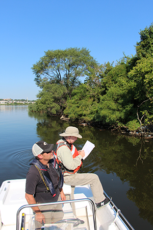
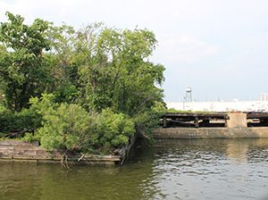
As land-based access is not always possible along industrial waterfronts, a water-based survey or one done by aerial drone is often required. The assessment is benefited with a photographic inventory, recording the conditions with digital photography and creating a photodatabase. The water-based visual survey also should characterize shoreline conditions, including a description and a classification of shoreline type into existing shoreline typologies (natural, rip-rap, bulkheaded, etc.). Borrowing from our history of assessing miles of streams with a systematic but rapid methodology, we sought to create a Qualitative Habitat Evaluation Index (QHEI) to document baseline conditions. The shoreline QHEI assessment focuses on similar parameters and metrics developed for coastal zones (Strickland et. al 2010), modified shorelines (SMCMA, 2009), and estuarine bottom dwelling features (Llanso and Dauer, 2002). The shoreline QHEI rating system is composed of parameters and metrics that describe the physical and biological conditions that contribute to supporting a robust shoreline habitat, which impacts native plant and animal communities. The complete list of parameters includes: critical area quality, vegetative zone width, vegetative cover, sunlight availability, slope of bank, bank/shoreline stability, shoreline complexity, outfall pipes, epifaunal substrate and surface cover, offshore slope, depth within ten meters, SAV cover, and water clarity.
The systematic approach to the assessment provides a structure for compiling a consistent data set of shoreline form and physical characteristics. This, in turn, informs an understanding of the existing site’s ecological function.
A subset of the habitat evaluation parameters used to evaluate the existing shoreline quality are:
Critical Area Quality (specific to Maryland)
The “Critical Area” as passed by the Maryland General Assembly in 1984 in the Chesapeake Bay Critical Area Act is defined as all water and submerged lands of the Chesapeake Bay to the head of tide, and all land and water within 1000 feet of Mean High Water or from the edge of tidal wetlands. Certain restrictions on the use of land within this area were outlined in criteria passed in 1986 and are mandated by local governments. Critical area quality takes into account the vegetated buffer quality along tidal waterways (filters runoff), associated population density (land use impacts), industrial presence (contaminants) and paved surfaces (quality of runoff).
Vegetative Zone Width
The width (depth of vegetated buffer from the shoreline landward) includes a diversity of native species and large continuous tracts with limited human activity preferred. Increasing the zone width would ideally allow room for a diverse vegetative community to be planted or naturally develop. Intertidal marsh grasses, shrubs and upland transition trees create multiple structural levels as habitat as well as provide layers of buffer from waterward forces and filtration capacity from landside runoff.
Slope of Bank
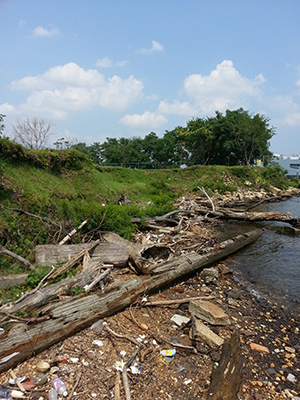
Slope of Bank estimates the general bank slope across the zone of evaluation from upland to tidewater. As one of the significant physical factors determining the quality of habitat, slope directly impacts vegetation (species, distribution, quality), erosion potential, trash accumulation and habitat quality.
Shoreline Complexity
A significant physical factor determining the quality of habitat, shoreline complexity is identified by more diversity in channel and bank structure intertidally, with non-uniform areas providing opportunities for tidal pooling and other microhabitats. Estuarine tidal wetlands, intertidal oyster reefs, sandy overwashed shell beaches, undercut forested shores and eroding cliff sides provided this complexity.
Epifuanal Substrate and Surface Cover
This parameter refers to the available stable surfaces for aquatic animals (fish and invertebrates) to live on, or find shelter within. These surfaces are often characterized by organic natural materials that have cracks and crevices with a diversity of types: logs, trees/roots, shell accumulations, rocks, etc. An opportunity and a challenge in urban environments is that this parameter is found in remnant human created structures.
SAV Cover
Submerged Aquatic Vegetation (SAV) Cover provides critical habitat for a variety of native fish and invertebrates, especially as a refugia for juvenile species. Additionally, the structure of the SAV beds can dampen wave energy, naturally filter and settle out suspended sediments, and through photosynthesis increase levels of dissolved oxygen locally. As SAV needs shallow waters with good light penetration and low energy to survive, it is often an indicator of good water quality with regards to turbidity.
Step 2: Guiding the Design
Understanding typical existing shoreline conditions also begins to inform the development of restoration concepts for alternative typologies that promote ecological enhancement and improved function. Contained within the QHEI are a set of parameters and metrics that can guide the design to provide greater function for the habitats created and increased ecosystem services.
While site specific, there are several design guidelines that may be considered universal to most shorelines, specifically those typologies proposed for former urban industrialized sites:
- Establish a wider zone of native vegetation providing habitat for wildlife, stormwater infiltration and absorption, flood/storm surge protection and aesthetic enhancement.
- Add complexity to the edge through the selective removal or modification of hardened shoreline and the development of a tiered vegetated edge that includes native coastal scrub/shrub vegetation and tidal wetlands.
- Consider fetch when determining placement of the proposed design alternative within the intertidal zone; consider depth, and distance offshore based on wave energy in design feasibility analysis for offshore design alternatives.
- Examine water depth to bottom within approximately 30 feet of the existing riprap edge to determine width of shoreline expansion.
- Create a maintenance plan to maintain vegetative habitat and clear any large woody debris or floatable trash deposition that could impede survival of shoreline vegetation.
In urban and historically industrial sites, it should be particularly noted that potential contamination of in-situ soils is a real and important consideration for many shoreline redevelopment and restoration projects. If excavation of contaminated soils is required, the designer and developer will need to include an appropriate and approved cap or liner before beginning restoration of the shoreline above the cap. Clean fill should be used for above the cap and proposed fill in waters of the U.S. will require permits from the USACE and the State.
Step 3: Evaluating the outcome
Investments in revitalizing urban waterfronts is likely to continue, even as coastal flooding due to sea level rise and storm surges occur with greater frequency. But these investments should look beyond the anthropocentric metrics of success and strive to serve the ecological community living at or beyond the water’s edge. These shorelines can become high performance ecological landscapes, if designed appropriately. The best way to measure that performance is to establish baseline ecological conditions and then perform regular follow-up monitoring of key biological and physical parameters. Upon design and implementation, the QHEI can be performed again to evaluate the quality of the habitat. Ideally, a more detailed quantitative survey of each site’s specific shoreline physical and biological conditions should be conducted. And with this tool, there is at least an initial means and data to evaluate whether ecological benefits were realized following a waterfront revitalization.
References for this article are in the Resources section of Leaf Litter.
Upon asking this question, we realized there is likely no simple answer, as each city and its waterfront, holds unique characteristics that affect ecological function. Generally, most urban waterfront revitalization efforts have not focused on the ecologically rich ecotone where the water meets land. A structurally complex and relatively stable shoreline provides unique habitat opportunities that support a diverse aquatic community. When upland shoreline vegetation transitions into intertidal zones with wetland and shallow water aquatic plants, this supports healthy invertebrate, fish and water bird communities that utilize and often gravitate to shoreline environments. Modified and straightened shorelines armored with concrete bulkheads or riprap offer very narrow areas of vegetation, provide little ecological function, and hinder natural sediment deposition and erosion. With no standard method for assessing and documenting urban shoreline conditions and no standard design guidelines on what physical characteristics might yield improved ecological function along a revitalized urban shore, we have sought to collect references and develop a process for quantifying ecological function and benefits.
As land-based access is not always possible along industrial waterfronts, a water-based survey or one done by aerial drone is often required. The assessment is benefited with a photographic inventory, recording the conditions with digital photography and creating a photodatabase. The water-based visual survey also should characterize shoreline conditions, including a description and a classification of shoreline type into existing shoreline typologies (natural, rip-rap, bulkheaded, etc.). Borrowing from our history of assessing miles of streams with a systematic but rapid methodology, we sought to create a Qualitative Habitat Evaluation Index (QHEI) to document baseline conditions. The shoreline QHEI assessment focuses on similar parameters and metrics developed for coastal zones (Strickland et. al 2010), modified shorelines (SMCMA, 2009), and estuarine bottom dwelling features (Llanso and Dauer, 2002). The shoreline QHEI rating system is composed of parameters and metrics that describe the physical and biological conditions that contribute to supporting a robust shoreline habitat, which impacts native plant and animal communities. The complete list of parameters includes: critical area quality, vegetative zone width, vegetative cover, sunlight availability, slope of bank, bank/shoreline stability, shoreline complexity, outfall pipes, epifaunal substrate and surface cover, offshore slope, depth within ten meters, SAV cover, and water clarity.
The systematic approach to the assessment provides a structure for compiling a consistent data set of shoreline form and physical characteristics. This, in turn, informs an understanding of the existing site’s ecological function.
A subset of the habitat evaluation parameters used to evaluate the existing shoreline quality are:
Critical Area Quality (specific to Maryland)
The “Critical Area” as passed by the Maryland General Assembly in 1984 in the Chesapeake Bay Critical Area Act is defined as all water and submerged lands of the Chesapeake Bay to the head of tide, and all land and water within 1000 feet of Mean High Water or from the edge of tidal wetlands. Certain restrictions on the use of land within this area were outlined in criteria passed in 1986 and are mandated by local governments. Critical area quality takes into account the vegetated buffer quality along tidal waterways (filters runoff), associated population density (land use impacts), industrial presence (contaminants) and paved surfaces (quality of runoff).
Slope of Bank
Slope of Bank estimates the general bank slope across the zone of evaluation from upland to tidewater. As one of the significant physical factors determining the quality of habitat, slope directly impacts vegetation (species, distribution, quality), erosion potential, trash accumulation and habitat quality.
Shoreline Complexity
A significant physical factor determining the quality of habitat, shoreline complexity is identified by more diversity in channel and bank structure intertidally, with non-uniform areas providing opportunities for tidal pooling and other microhabitats. Estuarine tidal wetlands, intertidal oyster reefs, sandy overwashed shell beaches, undercut forested shores and eroding cliff sides provided this complexity.
Step 2: Guiding the Design
Understanding typical existing shoreline conditions also begins to inform the development of restoration concepts for alternative typologies that promote ecological enhancement and improved function. Contained within the QHEI are a set of parameters and metrics that can guide the design to provide greater function for the habitats created and increased ecosystem services.
While site specific, there are several design guidelines that may be considered universal to most shorelines, specifically those typologies proposed for former urban industrialized sites:
- Establish a wider zone of native vegetation providing habitat for wildlife, stormwater infiltration and absorption, flood/storm surge protection and aesthetic enhancement.
- Add complexity to the edge through the selective removal or modification of hardened shoreline and the development of a tiered vegetated edge that includes native coastal scrub/shrub vegetation and tidal wetlands.
- Consider fetch when determining placement of the proposed design alternative within the intertidal zone; consider depth, and distance offshore based on wave energy in design feasibility analysis for offshore design alternatives.
- Examine water depth to bottom within approximately 30 feet of the existing riprap edge to determine width of shoreline expansion.
In urban and historically industrial sites, it should be particularly noted that potential contamination of in-situ soils is a real and important consideration for many shoreline redevelopment and restoration projects. If excavation of contaminated soils is required, the designer and developer will need to include an appropriate and approved cap or liner before beginning restoration of the shoreline above the cap. Clean fill should be used for above the cap and proposed fill in waters of the U.S. will require permits from the USACE and the State.
Step 3: Evaluating the Outcome
Investments in revitalizing urban waterfronts is likely to continue, even as coastal flooding due to sea level rise and storm surges occur with greater frequency. But these investments should look beyond the anthropocentric metrics of success and strive to serve the ecological community living at or beyond the water’s edge. These shorelines can become high performance ecological landscapes, if designed appropriately. The best way to measure that performance is to establish baseline ecological conditions and then perform regular follow-up monitoring of key biological and physical parameters. Upon design and implementation, the QHEI can be performed again to evaluate the quality of the habitat. Ideally, a more detailed quantitative survey of each site’s specific shoreline physical and biological conditions should be conducted. And with this tool, there is at least an initial means and data to evaluate whether ecological benefits were realized following a waterfront revitalization.
References for this article are in the Resources section of Leaf Litter.
